


Radaway | Mayday, Mayday, Mayday!
Awards & Nominations
Radaway has received the following awards and nominations. Way to go!
 Galactic Impact

The Challenge | Mayday, Mayday, Mayday!
Radaway
A balanced, personal perspective on the quantities and risks of radiation.

Note: There are a few missing images, as the editor seemed to flake out, keep an eye out for the links.
Explanation
Frequentflyers and flight crew often spend in excess of 20 hours per week in flight.This, along with the flight path they take and date, mean they are exposed toionising radiation at higher/varying rates than the general population. Butexisting tools to check on radiation exposure are unwieldy and confusing touse, resulting in poor understanding and uptake. We propose an app to bridgethis communication gap by both logging exposure easily, and expressing quantityand risk in easy to understand terms.
Summary
Initially we looked at the challenge in a more technical way-visualizing flight paths and radiation exposure, 3D representations, flightroute optimization, solar storm warnings and the like. But we couldn't ignorethe confusing mess of graphs in front of us! How is the average person going toquickly understand their level of risk from this?

We took a step back and decided to look at it fromthe perspective of the public, choosing the most regularly exposed groups- aircrew and frequent flyers. Sure, we could make something that gives them anumber, but so what? How are they going to understand that in relation to othersources of radiation they are exposed to, and what's the increase in risk?
We set up phone interviews with 5 senior flight crew(>30 years service), a frequent flier and a risk analyst in the airlineindustry.
Insights frominterviews
Specifics regarding airline policy, flight crewawareness, processes regarding radiation dosage quotas etc were uncovered. The salient points:
- The airline just gives a number to the flight crew
- The flight crew know that when they hit their action limit (6 micro Sievert) they may need to adjust rosters
- They generally check it once or twice a year, but apart from the relationship with their quota they have no further understanding of it
- Flight crew generally know that some routes increase their exposure compare to others
- Flight crew and Frequent Fliers are often more concerned with the radiation from full body scanners in security than radiation from a flight
- Passengers never ask about radiation exposure
- Flight crew do think twice about flying a lot if pregnant
- When pregnant, a woman's radiation action limit is reduced to the level of the general public, as the unborn baby is considered the general public
- Flight crew sometimes wonder if the radiation exposure over their entire career is something to worry about
For full documentation of our UX process, check out Moses' blog post:
https://medium.com/@mosesandersonong/nasa-space-ap...
And now we know who Marissa Musk is:

With these insights in mind how can we keep trackof ionising radiation exposure in an easy to check way, but also relate it toexposure from other sources and the increased risk? After all, what good is anumber without a sense of proportionality and perspective? This is informationcould inform future decisions by both these people and airlines.
How it works -Quantifying Exposure
The first step is data input, but entering flightsisn't a priority on a Sunday afternoon or 15 minutes after you land. So wepropose to enter an email/frequent fliers/ERP login to automatically trackthis, with a manual fallback. Likewise, a GPS/location service change on aglobal scale within a day could prompt a quick question and flight choice. Oncethe data is entered the appropriate past radiation data can be computed andpulled in. Future flight dates (if Marissa wants to see how much of an impactit would have) can also be explored.
We'd love to post this image here, but the editor seems to be uncooperative, please click this link for a visual of the app workflow:
And now we have the radiation exposure per flight,and monhly/yearly cumulative. But, it's still just a number.
Apples to Bananas:
Note that we couldn't paste in an updated image, for the LATEST version click this link:
Older version that we'll leave here for now:

Remember that security gate Marissa was nervousabout? She'd need to go through it over 16,000 times to exceed her currentmonthly flight exposure. Or on the flipside- if she got a chest CT scan that would be 7000 micro Sieverts!
Quantifying Risk
Mortality from low doses of ionising radiationexposure follows a linear relationship via the LNT model. Compared to thegeneral public which have a yearly background radiation exposure of approx 3milli Sieverts, flight staff often add another 3 or 4 of Cosmic Radiation,bringing their total to approx 6 milli Sieverts. This doubles their risk ofmortality from ionising radiation.
Putting that into perspective, using the LNT model the mortality rateadds up to about 1% (cause of death) if you aren't crew. If you ARE crew andhave a 30 year career it's now 2% (refer to the BEIR IIV stage 2 report). Sure,an increase of 100% sounds like a lot, but in the context of the other leadingcauses of death Marissa shouldn't panic:

But what if you showed that increase in mortal riskcompared to the flu? Or the risk that radiation from THIS flight is greater orsmaller than the plane crashing? Again, another fantastic opportunity forexpressing proportionality and we wish we had more time to validate the dataand express it in a UI!
Opportunities
We considered where this could go… On the health sideof things, maybe the app could integrate with wearables to suggest how far torun to offset the increased risk in mortality. On the airline side they couldsoften their brand image by showing they not only cared, but managed the issueof radiation exposure. Operationally they would also find more engagement withstaff that need to be aware of how exposure affects rosters.
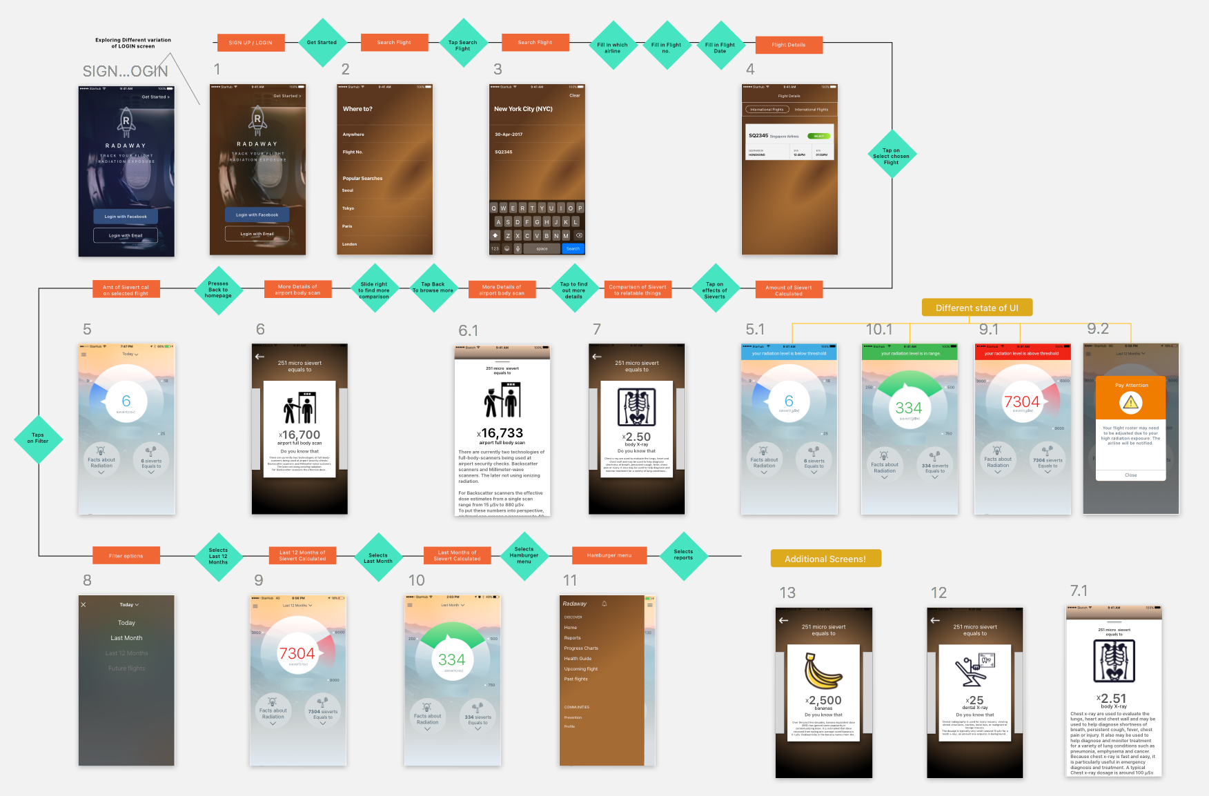
User Journey / Prototype UI/UX
For full documentation of our UX process, check out Moses' blog post:
https://medium.com/@mosesandersonong/nasa-space-ap...
Team
Martin Sawtell
Effects Technical Director, Lucasfilm
www.msawtell.com
Harald Battran
Consultant / Project Manager
www.connecting.sg
Roger Iles, PhD, MSci
Risk Consultant
Moses Ong
UX Researcher I Designer
mosesandersonong@gmail.com
https://www.linkedin.com/in/mosesanderson/
Mark Ong
UI/UX Designer
https://www.linkedin.com/in/markebenezerong/
References
BEIR VII, Phase 2 2006: Health Risks from Exposure toLow Levels of Ionizing Radiation
http://www.msawtell.com/zzTemp/beir_vii_final.pdf
https://www.nap.edu/read/11340/chapter/1
The Linear No-threshold model (used to model effect of radiation on health)
https://en.wikipedia.org/wiki/Linear_no-threshold_model
Qantas and Virgin airline policy on staff exposure toionising radiation
(Notavailable publicly) But please refer to these EU findings in-place:
https://ec.europa.eu/energy/sites/ener/files/docum...
Flight path calculators for exposure verification
http://sol.spacenvironment.net/raps_ops/current_files/FlightPath.html
http://jag.cami.jccbi.gov/cariprofile.asp
Full body security scanner emissions:
http://www.sciencedirect.com/science/article/pii/S...
Additional Research / Resources used:
IFALPA - 13MEDBL01 - Cosmic Radiation
PATRAM 2016 - Paper 2063 - Flight-Time Equivalent Dose – A Concept toContextualize Radiological Dose
CIEMAT Radiation Protection Service - Radiationprotection Program for aircrew members at Iberia L.A.E..
HPS - Fact Sheet - January 2010 - RadiationExposure from Medical Exams and Procedures
Data sources
GOES HEPAD particle flux measurements
Ground level monitor (GLM) neutron measurements
NOAA sunspot cycle data together with forecastedsunspot number
OAG flight route and airports database

SpaceApps is a NASA incubator innovation program.