


BeachPal | Let's go to the Beach!
The Challenge | Let's go to the Beach!
BeachPal
BeachPal aims to keep everyone safe and happy on the beach.
There's nothing better than a nice day at the beach, but sometimes the trip is ruined by things like a sunburn, too much or too little waves, or unpleasant/dangerous weather conditions. Sometimes it turns out there was another nearby beach that would have been great, but how would you know? There are ways to research ahead of time, but it involves a lot of steps: Checking the weather, looking up the locations in something like Google Maps, seeing if there's a name for that beach and if anyone has reviewed it so you can skim through tourism articles or municipal websites. Dangerous conditions are reported in local media, but you have to know where to look, and there's often lagtime. There are pretty detailed surfing forecasts for surfing enthusiasts, but very little for the general public. Serious dataheads make up a very small percentage of beachgoers. What usually happens is people just get their bathing suits, towels and cooler together and hope for the best.
This sometimes has tragic results. For example: Recently in Santa Cruz, two young men drowned because they were unaware the tide was coming in. There are beaches with riptides or undertows at certain locations and times of day, but swimmers can't see them and there isn't always a lifeguard on duty.
Fortunately, the data is out there, with lots of predictive capabilities thanks to the enormous datasets provided by the National Weather Service and NASA. Crowdsourcing bolsters this too. Think Waze for beaches, but instead of flagging a speed trap or stopped vehicle, someone flags a shark sighting, or a surge of stinging jellyfish or sandflies.
So, lets build a nice RESTful API to pull all this together and serve it out to some user-friendly apps. Hello BEACH PAL!
When beachgoers are planning their trip, Beach Pal provides an easily searchable interface to find a beach based on location and other preferences. At the beach, Beach Pal can help with such things as remembering to reapply sunblock, or tracking the times of day with highest or lowest UV exposure. This is important because someone dies of skin cancer every 54 minutes.
We have a prototype showing the basic features of the app here: https://xd.adobe.com/view/895a0e97-c00a-4006-bd55-... Our progress so far on the Android app is on GitHub (https://github.com/akul-goyal/NASA201) and we've started the first steps of a Node.js backend that would tie it all together. For the hackathon we depended mostly on http://openweathermap.org/ for our database.
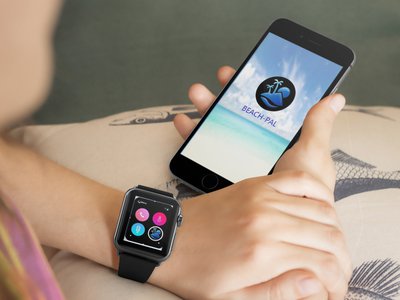
One cool feature is the ability to connect to a waterproof wearable so users are more immediately aware of potential dangers. The wearable would also be a more effective reminder system for sun protection. Here's a wireframe showing that interaction: https://app.moqups.com/susan.zell@gmail.com/YaSdbl...
Another neat possibility for the future is making an Alexa skill (and Google Home etc.) for planning and integrating with connected car systems for finding a beach on the go.
There are a few websites that make some headway in bringing important info to the beachgoing masses, but usually they're usually limited in geographical scope or require significant STEM literacy on the part of the user (c.f. http://tides.willyweather.com/ca/santa-cruz-county...http://www.floridahealth.gov/environmental-health/...). They're not necessarily particularly mobile-friendly either.
Our planet is mostly water, and everyone should get out and play in it every once in a while. Beach Pal makes that easier and safer. Check out our PowerPoint here: https://drive.google.com/file/d/0B8YKoeXRIvRwUnRSZ...

SpaceApps is a NASA incubator innovation program.