


OgrooPothik | Let's go to the Beach!
Awards & Nominations
OgrooPothik has received the following awards and nominations. Way to go!
The Challenge | Let's go to the Beach!
Beach Alert
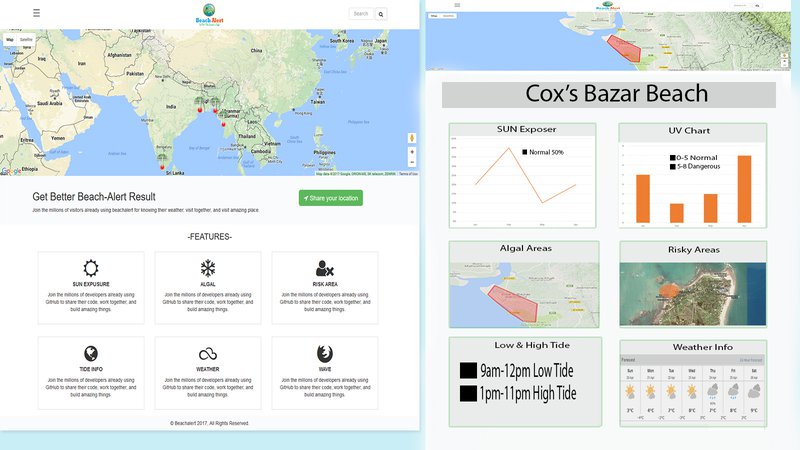
Our App will give alert to beach goers about sun over exposure , UV over exposure, Algal areas, Quick sand areas, high tide-low tide, cloudiness of sky ,rough sea, humidity and weather info.
Background:
Don’t get Roasted In The Burning Sun Anymore :
Our software will give it’s users proper time to go the beach to avoid serious sun burn . Even though they want to enjoy the beach in the burning sun , we will advice them to take essential measures to take decision for avoiding skin damage.
Say Goodbye To Rash And Allergy:
Beach comers come to beach with exciting face and full of energy but return with some interesting skin colors thanks to algal content present in water. Using data provided by NASA API we will give them proper advice to choose algal free beach
Excessive Vitamin D is Not Good at all :
UV rays at reasonable amount is good for making vitamin D in body but at the same time over exposure to UV is a main reason behind skin Cancer. So, we will aware the users about the over exposure of UV .
Don’t fall into Quick Sand:
Beach goers don’t know about quick sand and risky area . So, we will aware the users about quick sand and risky area of the beach.
Resources Used:
We are using data given by NASA API ( https://neo.sci.gsfc.nasa.gov/view.php?datasetId=AURA_UVI_CLIM_M, https://neo.sci.gsfc.nasa.gov/view.php?datasetId=C, https://neo.sci.gsfc.nasa.gov/view.php?datasetId=MY1DMM_CHLORA,) to aware our users and to give them alert.Our app works on both mobile and Web platform.We used google Geo location API to obtain our users location for giving them real time alert.
Challenges Faced:
NASA API do not provide real time data, their data is not properly arranged and their API is not user friendly at all.For this we had spent a lot of time to extract data.As their is no real time data available, We built a statistical model which was very challenging for us.
Interestingly there are some real time data available that mostly depend of our concerned areas . So, we can also verify our prediction.
We will give proper alert to a user by getting his/her Real-time Location.
We will collect quick sand and risky area information from local authority and beach goers for alerting users.

SpaceApps is a NASA incubator innovation program.