


MarinGalaxy | Live Smart
The Challenge | Live Smart
TreeCode
TreeCode is a web application for monitoring urban afforestation using IoT. Through crowdsourcing the data are sent to the cloud and made available to assist Public Management in Urban Tree Planning and Researchers in studies.
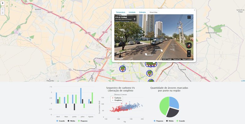
TreeCode is a web application for monitoring the urban afforestation using the concepts and applications of IoT (Internet of Things), gathering the data in a base located in the cloud. We identified here in the city that we live in, that the urban area of Maringá has one tree for each four inhabitants, an average of 44 m² of green area per inhabitant and a total of 1.8 million m² of green areas and with that several problems happen in Due to the difficulties of managing this large quantity of trees. This can be optimized and performed according to analyzes of the data collected directly from the trees. TreeCode aims to collect data from the trees with the support of the population (crowdsourcing), by a mobile application and send to the cloud, to treat and make available this data to assist the Public Management in the management and planning of urban afforestation and also to help Researchers , Scientists and Environmental Engineers in studies providing reliable and relevant information for research projects.
Microsoft ASP NET MVC-based Web solution, built on top of an MVC architecture using a RESTful services layer. TreeCode aims to collect data from trees with the support of the population (crowdsourcing), send to the cloud, treat and make available this data to assist the Public Management in the management and planning of urban afforestation and also assist Researchers, Scientists and Environmental Engineers In studies providing reliable and relevant information for research projects.
We use geoprocessing to render an interactive map using a JavaScript library called Leaflet that offers the possibility of connecting on a layer with WMS protocol to NASA servers that receive data from the Sentinel Satellite. For crowdsourcing, a hybrid mobile application was developed using Ionic and AngularJS that has the purpose of synchronizing the data emitted by IoT sensors installed in trees at strategic locations.
The Front End was built on Angular JS 4 with HTML 5 and CSS 3, on the server we used NodeJS and for the MSSQL Server database.It's online now! http://treecode.azurewebsites.net/

SpaceApps is a NASA incubator innovation program.