


Pizza Flyers | Pilots Plus
Awards & Nominations
Pizza Flyers has received the following awards and nominations. Way to go!
The Challenge | Pilots Plus
SkyTour
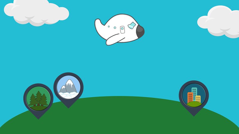
SkyTour is an app that allows passengers to keep track of the plane position on offline mode. By showing all places of interest they are flying over, passengers will enjoy an interactive trip experience through the power of augmented reality.
Have you ever gazed out the window of a flying airplane and wondered what you’re flying over?
Of course you have! We all have that natural sense of wonder that makes us want to explore our beautiful planet!
So… How this curiosity can be satisfied in a way that would not affect our free time and would save us from the boredom of the flight at the same time?
This is the question we kept in our mind for the most of Space Apps Challenge… until we came out with a creative solution!
PROJECT SkyTour
SkyTour is an app that allows passengers to keep track of the plane position on offline mode. By showing all places of interest they are flying over, passengers will enjoy an interactive trip experience through the power of augmented reality.
Our app is designed to be user-friendly, in fact the guidelines we followed for its UI are to keep it as intuitive as possible, to ensure that anyone can use it, from a curious child to a senior traveler!
HOW DOES IT WORK?
SkyTour take advantage of online aviation databases to calculate the route of the plane before the departure, so the user needs to access to the internet just one time before the travel starts!
The steps are:
- The user search for the flight using the Flight Code or entering few informations.
- Then he select the correct flight and SkyTour will start downloading the route and the data related to that flight and it will begin to create a map.
- The app will start tracing the user’s flight route on the map.
- When the flight will start, the user will enter the “Augmented Reality Mode” which will show him the points of interest he will see during his travel with the relative distance and some informations.
IS IT SAFE TO USE IT ON AIRPLANES?
Of course it is! We've designed this application to work totally offline because our users' security comes first.
We do not want services of your phone (eg GPS, Wi-Fi, etc.) to interfere with onboard devices while using SkyTour.
FUTURE PLANS
We have really big plans for the future of our app! We’re working right now to implement some very interesting features:
- Total integration with Wikipedia: Possibility to consult it offline the points of interest information on the user’s route by selecting their icons when they show up.
- Possibility to consult your favourites: SkyTour will save offline points of interest and favourite routes by user’s choice.
- Custom Notification: Users will be notified when the plane do some specific actions, like passing a border or is near a point of interest. Notifications will be customizables.
- Full integration with new generation devices (ex. wearables).
…More interesting features are yet to come!
OUR MATERIAL
SLIDES
OUR RESOURCES
SHARING CODE
MAP AND LOCATIONS
•https://developers.google.com/places/
APP SKETCHES
SLIDES
•https://www.apple.com/lae/keynote/
GET FLIGHT DATA
•https://openflights.org/data.html
FUTURE DEVELOPMENTS
•https://climate.nasa.gov/assets/images-of-change?id=605#605-heavy-rains-flood-peru

SpaceApps is a NASA incubator innovation program.