


CCIT-crazy top | 1D, 2D, 3D– Go!
Awards & Nominations
CCIT-crazy top has received the following awards and nominations. Way to go!
The Challenge | 1D, 2D, 3D– Go!
Angel-X:The Pioneer of Data Collector - More Gliding, More Efficiency
With Angel-X Gliding Dropsonde, we provide a more cost-effective and reusable solution to make up for the gaps in data collection and lower the cost of each mission.
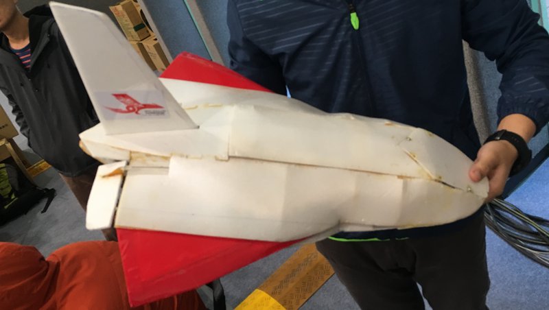
Introduction:Angel-X Gliding Dropsonde
Given the limitations (such as the low resolution of the entire structure of the storm) and inconvenience (the orbit of the satellite) of monitoring severe weather conditions (such as typhoons) using satellite.
→ANGEL-X allows for the collection of data from multiple sources, yielding images with better resolution of the object being observed.
→The average dropsonde is quite costly, averaging NT$20000 to NT$30000 (US$667 to US$1000) per unit, and collects the vertical profile of the atmosphere of a single location.
→ ANGEL-X prototype comes with a self-automated gliding flank
→ANGEL-X lowers the cost and improves the efficiency (allowing for horizontal data collection through gliding)
Dimensions:
Length x Width (with the wings spread) x Height:62.6x49x28.5(cm)
Weight:
Instruments onboard:temperature-humidity sensor DHT11, nine shaft gyroscope (pressure and vertical motion)
Cost: 7000NT/unit (approximately US$230)
How it works
Deployment in the air → opening of the flank(adjust aileron) → downward gliding and observation along the prescribed path →data collection → integrate data from NASA satellite → cloud computing, analysis, classification → establish a cloud database→ output of the data (3D visualization, prediction of the path and scale of the storm…)
Required resources
Hardware:Genuino101 board, nine shaft gyroscope, radio transmission modules (433HZ)
Software:satellite data, cloud computing, 3D visualization (PlotlyShiny)
How to use it
The aircraft brings ANGEL-X into the air and deploys it close to the typhoon.
→ collect observation data + satellite data(H20、IR、Sounder)
→ analyze, integrate (cloud computing), and create a database
→ 3D visualization of the structure of a typhoon
→ more accurate predictions of the track and the intensity of the typhoon
→ assess the impact of the typhoon and take contingency measures
Advantages
1.Lowering the cost of observation:
Currently, the average dropsonde costs around NT$20000 to NT$30000 (US$667 to US$1000) per unit, while our Gliding Dropsonde costs less than NT$10000 (US$333), which means a 50 to 67% reduction in the cost of observational equipment. With one single observation mission requiring 15 to 20 units of dropsonde, this translates into an NT$150000(US$5000) saving in equipment.
2.Fill in the gaps of the observation data:
(1) The dropsondes available on the market today collect the vertical profile of a single location. However, efficient and accurate monitoring of severe weather conditions usually requires a dense deployment of dropsondes. In addition, the observational data collected by the satellites of the severe weather conditions are often of insufficient resolution. This inability to render a more detailed visualization of the structure of the storm often results in the inaccuracy of the weather forecast and subsequent assessments.
(2) Our self-made Gliding Dropsonde is the ideal solution to insufficient data collection resulting from limited equipment. The Gliding Dropsonde has a longer descent with its gliding motion and allows for the collection of data on the horizontal profile of the atmospheric conditions at a certain altitude, hence increasing the density of data collection.
3. Shedding light on the blind spots of satellite observation of severe weather conditions:
By using improved data collection to establish a cloud database and incorporating 3D visualization of the structure of severe weather conditions, the blind spots (usually the bottom layer of the storm structure) of satellite observation are now brought under a new light.
4. Improve the accuracy in storm path prediction and risk assessment:
By providing central weather agencies with better and more comprehensive meteorological data along with the integrated analysis, a more accurate and detailed weather forecast can be made, allowing for better risk assessment and minimizing the damage done by severe weather conditions.
PDF-CCIT Crazy Top:
https://drive.google.com/file/d/0B5TRVdAbvA3TTWtjVDlDdDJaSUE/view
110 meter gliding dropsonde test:
https://drive.google.com/open?id=0ByeaZDpO-eHZQ054...
Dropsonde principles:
https://drive.google.com/open?id=0ByeaZDpO-eHZZktf...
Flying control code:
https://github.com/patrickwu1996/ccit-crazy-top
Black box code:
https://github.com/patrickwu1996/hackthonblackbox
NASA visualization:
https://drive.google.com/file/d/0B5TRVdAbvA3TSkFmM...
NASA-AIRS.2015.08.04 satellite data:
https://drive.google.com/file/d/0B5TRVdAbvA3TamlNc...
References
Video:How are Dropsondes Used?
From:NOAAMarineAviation
Literatures:
1. Evan Fishbein, Thomas Hearty, Sung-Yung Lee, Evan Manning and Edward Olsen: AIRS Level 2 Status.Jet Propulsion Laboratory/California Institute of Technology,
2.AIRS V6_Released_Processing_File_Description.pdf
3.吳俊傑,2013:追風十年回顧 – 中年 Wu & LinPo 的奇幻歷程 。中華民國氣象學會第五十四期會刊
4.NASA EARTH DATA SEARCH:https://search.earthdata.nasa.gov/search/granules?...

SpaceApps is a NASA incubator innovation program.