


Space Cowboys | Requesting a NASA Flyby!
The Challenge | Requesting a NASA Flyby!
WYSIWYG
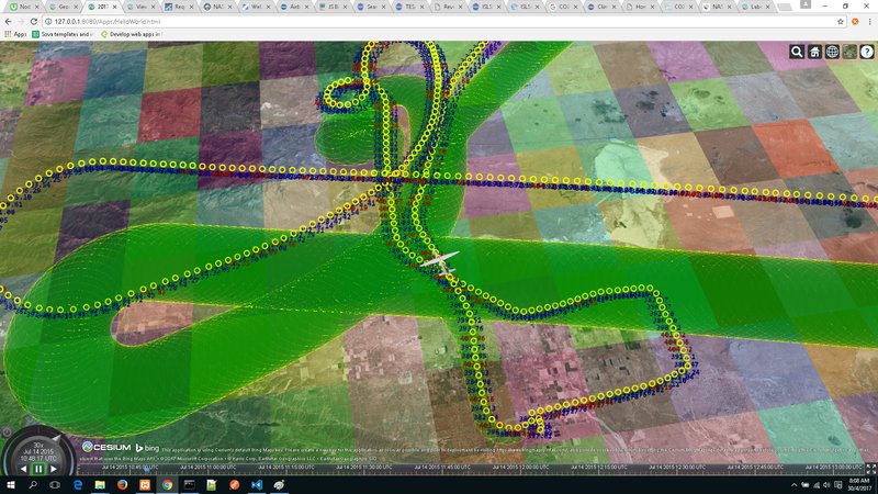
Visualization of ASP mission flight path, sensor readings and coverage
NASA’s Airborne Science Program (ASP) maintains and operates a suite of sustained, ongoing airborne platforms and sensors on which investigators can rely on to further science and advance the use of satellite data. These highly modified, innovative aircraft support:
- Testing and refinement of new sensor technology and components
- Calibration and validation of data from Earth-observing satellites
- Collection of air samples and in situ data that support Earth system models and satellite data processing
However, ASP’s ongoing capability will be resource-constrained and eventually technology-constrained, so that not all observing requirements will be met with the limited core capability. Thus, there is a need to make ASP flights as efficient as possible.
With this in mind, we decided to address the following:
- Analyze ASP flight tracks and path data and visualize the data in 3D. This can then be cross referenced with satellite path data to identify potential gaps in coverage
- Overlay the airborne sensor data and visualize it along the flight path. There are many different types of sensors on the aircraft so we decided to focus on just one (CO2 analyzer) to prove our concept.
- Overlay satellite sensor data for comparison and calibration purposes
We were able to download the ASP flight data from NASA but the onboard sensor data was not readily available. Furthermore, the satellite data was in JPEG form and was not ideal for cross-referencing. Nevertheless, by using sets of dummy data, we were able to demonstrate the proof of concept. We are very confident that our app will still be able to provide an accurate and representative visualization if given access to the airborne and satellite sensor data.
Potential future improvements include:
- The ability to select various historical paths of different airborne platforms.
- The ability to select various instruments and sensors
- If possible, provide real-time capability

SpaceApps is a NASA incubator innovation program.