


Salamander.se | Where the Genes Flow
Awards & Nominations
Salamander.se has received the following awards and nominations. Way to go!
The Challenge | Where the Genes Flow
Interactive model of gene flow
Model of the genetic flow of salamanders in Sweden. With a high resolution satellite data and GIS modelling we calculated the current and potential habitat and gene connectivity of red listed crested newts and made an interactive web-page.
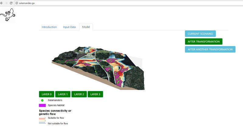
We have built an interactive model presented through the webpage www.salamander.ga that shows the potential habitat of endangered speceis and their ecological connectivity / or the genetic flow between habitats.
The page is designed in a way that allows to include the potential changes in the landscape, for instance, infrastructural changes that will directly affect the model output. Input data includes open source satellite data from NASA and species location from local species data-bank. The model takes into account species suitability environment using ecological profiles and maximum movement/dispersal distance. The model allows to use any species with any location in the world.
As an example, we use crested newts that are red-listed in Sweden and have a big population near Stockholm. The current scenario visualizes the current habitat and genetic flow. The future scenario shows the changes in the habitat and genetic flow due to an environmental impact such as expansion of the urban infrastructure.
Potential use:
- conservation projects
- urban development projects
- recreational projects
Potential user:
- anyone interested in nature, species, species habitat
- research organisations
- government
- business (construction companies, city planners)
Input Data:
Species location from http://www.artdatabanken.se/en/ - Swedish Speceis Information Centre
KNAS - Swedish land cover open data (based on Landsat, Sentinel)
OSM - roads from https://www.openstreetmap.org
Water ponds - Sentinel 2
Software:
QGIS, Java

SpaceApps is a NASA incubator innovation program.