


Team Go | Where's the Water?
Awards & Nominations
Team Go has received the following awards and nominations. Way to go!
The Challenge | Where's the Water?
GoWater
About 1.69 percent of earth's water is in the form of ground water and it is depleting rapidly. We aim to develop a one stop app so that everyone can understand the problem and a find a solution to it.
The Problem
Use satellite and other data to allow farmers, landowners, and land managers in your locale to identify and visualise water resources in their surroundings.
our solution
Before the solution it all begins with a story and a simple idea.
The story is simple, the one who is in the primary industry and is using the ground water regularly is knowingly or unknowingly exploiting it. It is high time now we tell the world that one of the most important form of water resource is getting depleted exponentially.
We came up with this idea of an App for anyone who wish to explore how trends are changing across continents in ground water level and the associated reason.
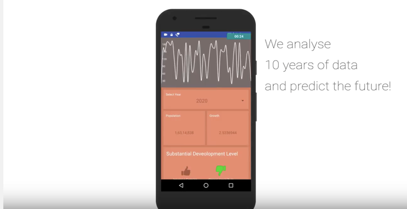
WaterGo, so how does this app works? We wanted to explore the data but it was confusing at first with a lot of data floating everywhere online, we scrapped everything we could starting from ground level indication from satellite, precipitation, frost and population nearby.
The User using the app can check if the land is sustainable for agriculture and what will be it's status in the near future
Concepts of deep learning helped us understand the trend of how global ground water levels have dramatically changed.
FUTURE ASPECTS
We plan to expand our app and make it more detailed. Add maps which shows the ground water level over the next 10 years to make it more interactive and easy to use. Add a compare feature so that land owners and farmers can easily determine where to buy the land.
CODE AND STANDARDS
- Python
- Java
- D3.js (JavaScript library)
resources
1) https://water.usgs.gov/ogw/times-sq
2) https://www.un-igrac.org/global-groundwater-inform...
3)http://databank.worldbank.org/data/reports.aspx?so...
4) https://www.esrl.noaa.gov/psd/data/gridded/data.gp...
5)http://libguides.mit.edu/gis/elevation
CODE SNIPPET
1)Android App:
https://github.com/mayankagg9722/NasaSpaceApp17
2)Machine Learning Data:
https://github.com/pranavdheer/nasa_Space_app
CONTRIBUTIONS
Anurag sarkar- Writing the Machine learning algorithms
Mayank Agarwal- Making the beautiful Android App
Navdeesh Ahuja- Making the attractive Ios App
Pranav Dheer- Serious research on data and algorithms
Subhanjan Chakraborty- Making the apps, presentations and the video perfect.
Rajarshi Bhattacharyya- Gathering data and processing.

SpaceApps is a NASA incubator innovation program.