


Aptech GDN Future Innovative | And YOU can Help Fight Fires!
The Challenge | And YOU can Help Fight Fires!
Fire Rescue
Fire Rescue is an App for fire fighters to rescue locals and save wild life from extreme dangerous situations with the help of crowd sourcing. Our mission is to build a strong communication system between them to get real data.
Rescue Fire
Introduction:
Fire Rescue is a unique App for fire fighters to rescue locals and save wild life from extreme dangerous situations with the help of crowd sourcing. Our mission is to build a strong communication system between people on the ground near areas of concern, Fire Agency and with Fire Fighters to get real time data and analysis quickly.
Objective:
To save lives by building a strong communication tool between on ground people with Fire agency and fire fighters to achieve accurate data by combining on ground data by user and data from NASA satellite.
Problem Statement:
- a)To find best path out.
- b)See the best paths available for rescue or fire management vehicles to enter.
- c)Estimate where post-fire effects will be the strongest.
Our Solution:
- a)Finding the best path by asking people on the ground near areas of concern and compare with data available from NASA Satellite.
- b)Fire fighter agency will receive data from people and from NASA data. Fire fighter agency will select best path in and out after analyzing data received from NASA and people.
- c)For post-fire effect we have analysis wind direction and speed of wind.
- d)Analysis relation between temperature and moisture with respect to time with the help of weather API. As temperature will increase moisture will decrease. And will cause fire spread rapidly.
- e)Will check nearby location. As there is mountains, residential area, or trees.
- f)If there are trees so we will check length of leaves as I would burn quickly. But there is deep forest so it will burn slowly and will create more smoke. Which is not good for human beings and animals.
- g)If residential area is near to fire and after analysis results about fire we will send notifications to users though app and training videos so users can help themselves and quickly news will spread
Fast as compare to any other media so people from far area would be aware of the future thread. And ready for security measure.
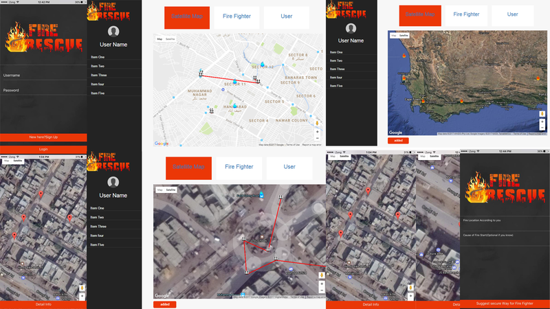
How it works:
Step 1: User will register to our Application by providing relevant credentials.
Step 2: Fire Agency will receive all user data.
Step 3: When user see’s fire in nearby place, he/she will provide information about the fire which included: Fire Location, Intensity of fire, Best possible path according to user by marking on Google Map and cause of fire if user know.
Step 4: Fire agency will receive notification of all user informed fire and verify with NASA active fire data.
Step 5: After receiving data from all the users, Fire agency will select best path to enter and exit.
Step 6: Fire agency will guide fire fighters via google map after selecting best path and live data from NASA and data collected by on ground local people.
Step 7: Fire Agency will send emergency alert to all nearby areas for health hazards and possible natural disasters might occur after fire eruption.
User Roles:
- Admin (View user data, user provided data about fire, NASA live data of fire, add fire fighters, find best secure path through user give paths via Google Map API, send notification to nearby area and to fire fighters)
- Fire Fighter (Will receive best path from Admin via Google Map API which is provided by user)
- User (Will provide all the data about active fire to Admin which includes fire location and best suitable path)
Outcome of our Projects:
- To save as many wild life, human life and nature from wildfires by providing right person accurate data from user and NASA.
- To save nearby areas from health hazards, climate changes and smoke.
- To predict future natural disasters in nearby areas like landslide, flooding, debris flows)
Resources:
- Firebase as Database
- Cordova Plugin
- Google Map API
- Angular 2.0
- TypeScript ES6
- Weather API
- SQLite as a Local Database
Challenges Faced:
Facing challenges are always is best way to learn something new. We learn following during this project.
- Finding relevant data from the right source.
- Using NASA Data in our project.
- Using third party API’s.

SpaceApps is a NASA incubator innovation program.