


Delta | And YOU can Help Fight Fires!
Awards & Nominations
Delta has received the following awards and nominations. Way to go!
The Challenge | And YOU can Help Fight Fires!
Saving the Woods
Wildfires cause massive destruction. "Saving the Woods" is our solution to stop fires that occur in the wilderness.
With our project called ,,Saving thewoods”, we drastically reduce the response time of firemen, saving millions oflives and preserving nature. At thesame time we prevent deforestation. This is why we chose this challenge.
Firstly, to solve the problem we must assess where the fire is spreading from. How do we achieve this?
Using the information from Suomi National Polar-orbiting Partnership Visible Infrared Imaging Radiometer Suite (S-NPP/VIIRS) active fire detection product based on that instrument’s 375 m nominal resolution data, we mapped the hazardous areas from the past year where a fire can start.
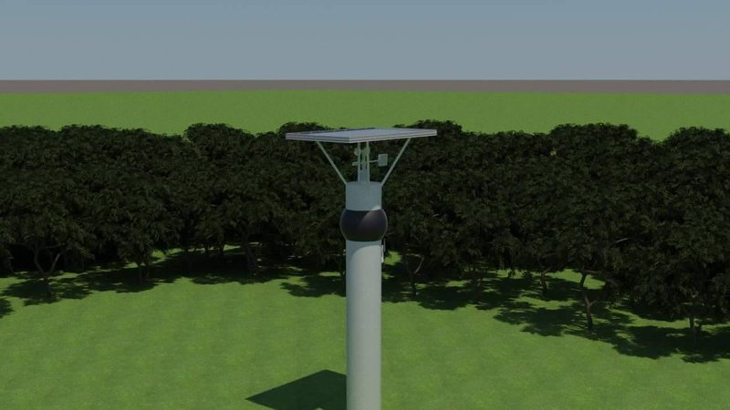
In these hazardous areas thermal 360 cameras (
Simultaneously, wind speed and wind direction sensors are placed, to send key information to the database. It is imperative to determine the direction in which the fire will spread. This will be achieved with the MISR instrument aboard the Terra satellite with which we’ll measure the wind direction. It will be crucial for fighting these massive fires as it will provide a larger picture. The previously mentioned wind speed and wind direction sensors, also connected to the router, will supply information on the momentary wind condition. They will not need power as they are powered by the wind as they calculate its speed. If the wind passes the 8.8km/h mark, they will have reached their maximum need and they can store even more power, making the system even more sustainable and stable. They send the information to the database and an algorithm is developed to determine where the fire will spread. In our application DeltApp, the algorithm will be used both for the firemen to put out the fire as soon as possible and to help the civilians as well.
*Alternatively, instead of using routers, the thermal cameras could send information through the LORA network, which is fairly new but functional in many parts of the world, and is used in our country as well.
The thermal cameras are connected to a service and the data is stored in our database.
The firemen are alerted that a fire has started, and through the IP address of the router connected to the camera which first registered a fire, they locate it and thus find out where the fire is spreading from. This is achieved with the desktop version of our application. It incorporates both the data from NASA’s satellites and this information sent from the routers. The application has both a desktop and mobile version, and the desktop version will be installed on every computer in the fire stations.
The mobile application helps civilians to be informed about the fires near them, it allows them to report a fire and immediately locate it so help can arrive quicker. It also contains tips for how to put out/manage a fire, and depending on the meteorological conditions such as winds, heat, humidity it will provide a path away from the fire for the people to follow. The path will be provided based on the previously mentioned algorithm, which depending on the direction and speed of the wind, will calculate where the fire will spread.
The challenges we face:
Protecting our sensors from thunderstorms, rain, hail, and the high temperatures which might damage the camera.
The poll on which the camera is set will not suffer from a direct hit from lightning as it is not grounded, but it might be damaged from lightning which has struck nearby. To solve this problem we will install polarized filters so the sensor will not sustain damage. As for the data processor we’ll have an algorithm to make sure that if there is a sudden white light spike it will not report it as a fire so there are no false alarms.
RESOURCES USED:
VIIRS ACTIVE FIRE PRODUCTS
AIRS SATELLITE IMAGERY
MISR STALLITE IMAGERY
AGENCY FOR SPACIAL PLANNING OF MACEDONIA
HEADQUARTERS OF THE FIRE BRIGADE OF SKOPJE
Link to power point presentation containing additional photos of the app and sensors: https://drive.google.com/open?id=0B3aCPzjYK8FqTzUw...

SpaceApps is a NASA incubator innovation program.