


FireBenders | And YOU can Help Fight Fires!
The Challenge | And YOU can Help Fight Fires!
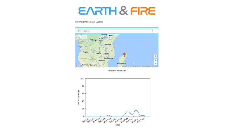
Earth & Fire
Earth and Fire is an intelligent app that can predict natural fire hazard rate for any geolocation in any future time-frame. It analyzes NASA earth observation data using time series analysis and also a crowd sourcing and notification feature is included.
Fire was once considered as one of the four basic elements of the universe by the Greeks. In one Greek myth, Prometheus[1] stole fire from the Gods to protect the otherwise helpless humans, but was punished for this charity. That’s not the case, we now have proved that but we can’t deny that, fire is one of those inventions has lead our civilization this far. From daily house hold cooking to Rocket science everywhere there is gesture of this great scientific phenomenon. But like every other blessings of nature, it also has its curses. Wildfires, peat fires and controlled burns on farming lands kill 339,000 people worldwide each year according to a study[2]. An article[3] of Scientific American suggests that large scale wild fires easily do more than $1 billion dollars in damage.
This large number of causalities and property damage motivated us to design an intelligent system that will predict natural fire hazards using best computing algorithm. Our research led us to NASA Earth Observation (NEO)[4] global Active Fire Data. We find that data helpful for our project.
After finding the proper data set we began analyzing that. We use grayscale satellite image provided by NASA and generate data using Python Programming Language. After that those data are used to create forecast model for next 1 year. In practical purpose, we are using NASA Earth Observations Global Active Fire Data from 2000 to 2016 and predicting fire hazard for 2017.
We also have included a crowd source feature in our application. Using this feature, users can report fire hazards from there device and after verifications Earth & Fire will notify other users near the affected zone. There is also an Application Program Interface for the authority and researchers to get data about active fires all over the globe.
Used Resources:
Due to limited computing power we had to compromise some features of our original project plan. We need more processing power for more accurate and detailed prediction.
GitHub : https://github.com/arman-bd/earth-and-fire
[1] Greek demi-God
[2]https://www.ncbi.nlm.nih.gov/pmc/articles/PMC33468...
[3]https://www.scientificamerican.com/article/graphic...
[4]https://neo.sci.gsfc.nasa.gov/view.php?datasetId=M...
[5]ftp://neoftp.sci.gsfc.nasa.gov/gs/MOD14A1_E_FIRE
[6]https://firms.modaps.eosdis.nasa.gov/download/
[7]https://github.com/facebookincubator/prophet
[8 ]https://developers.google.com/maps
[9]https://cesiumjs.org/

SpaceApps is a NASA incubator innovation program.