


Fluskat | And YOU can Help Fight Fires!
Awards & Nominations
Fluskat has received the following awards and nominations. Way to go!
The Challenge | And YOU can Help Fight Fires!
Fire Fighting Eagle
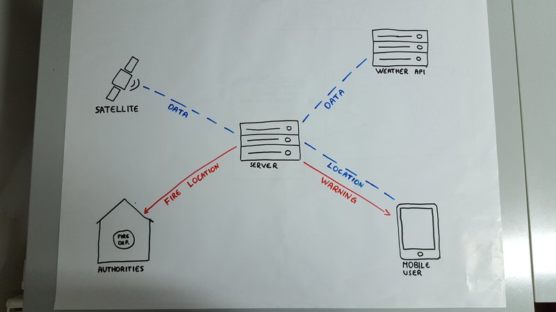
The app combines NASA’s satellite real time imagery data, weather data and crowdsourcing to be able to predict and locate wildfires around the world and calculate their spreading direction. Warn people and notify local authorities.
Wildfiresare uncontrolled blazes fueled by weather, wind, and dry underbrush. Wildfires can burnacres of land and consume everything in their paths in mere minutes. Accordingto their catastrophic consequences we must pay attention and find a solutionfor this threat.
We are building an app which combines NASA’s satellite real time imagery data, weather data and crowdsourcing to be able to predict and locate wildfires around the world and calculate their spreading direction. We have found a solution to warn people and notify local authorities located near an active fire zone. After people get to a safe place, they send us a picture with the location. This way we get a safe path for evacuation and for local authorities to reach a wild fire zone as fast as possible.
Data sources:
- NASA's active fire data will be obtained and used to monitor and locate anomalies on the Earth surface.
- Weather forecast data will be used to calculate and predict potentially wildfire areas, evaluate the spreading direction of a wildfire.
- Crowdsourcing helps finding paths from people that receive wildfire warning and are the first ones to escape to a safe location. While we keep tracking users on dangerous areas, we keep updating safe paths on our map for other people and local authorities.
- All this data will be collected and processed in the server in real time.
Future Developments:
- Predicting spread of ash and smoke in real time and visualizing it in the map.
- Burned area mapping and flood chances during rainfall.
- Calculating landslide probability in burned areas.
Github:
https://github.com/agoncecelia/FireFightingEagle
https://github.com/agoncecelia/FireFightingEagleBa...

SpaceApps is a NASA incubator innovation program.