


gWaves | Mayday, Mayday, Mayday!
Awards & Nominations
gWaves has received the following awards and nominations. Way to go!
The Challenge | Mayday, Mayday, Mayday!
Web-based App Radiation Management (WARM)
The Web-based Application Radiation Manager (WARM) is a microservice that calculates and visualizes the radiation exposure for an actual or hypothetical flight.
Exposures to ionizing radiation represent real health hazards to all flight travellers. Prolonged ionizing radiation exposures may lead to biological effects such as: damage of immunization system, cancer, and hereditary effects. In 2016, there were over 3 billion flight passengers (crews not included). Flight attendants spend on average 1400 hours in the air per year and pilots no more that 1000 hours per year.
How do we ensure ionizing radiation exposures for all flight travellers are within the established dose limits?
The Web-based Application Radiation Manager (WARM) is a prototyped microservice that calculates and visualizes the radiation exposure for an actual or hypothetical flight. WARM also provides a set of APIs available for developers.
WARM is based on the Single Page Application (SPA) architectural pattern and therefore is a web site that fits on a single web page with the goal of providing a fluid user experience. All the necessary code - HTML, JavaScript, and CSS - is retrieved with the single page load. The appropriate resources (waypoints, cosmic radiation calculation, maps) are dynamically loaded and added to the page as necessary, in response to user actions.
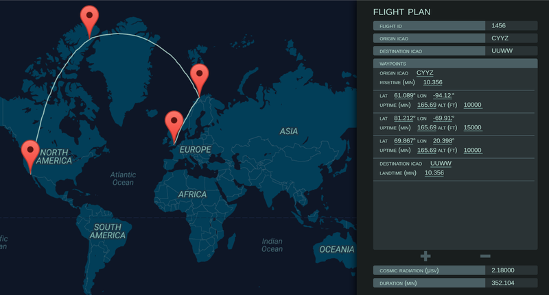
In the application, a user can either enter a flight ID or the individual waypoints / elevation / duration to check the level of cosmic radiation he/she has been exposed during a flight.
Looking forward, we would like to grow the WARM microservice and APIs to provide the capability to:
- enable flight passengers to monitor their individual ionizing radiation exposure dosage on a cumulative basis (year to date for example);
- incorporate the effects of significant solar particle events in the calculation of cosmic radiation exposure
enable managers to monitor ionizing radiation exposure dosage for all flight crew members within an airline carrier and to help with flight assignment planning; and
Link:www.fleepy.space
Github repository:
https://www.github.com/Ercadio/FlightRadiationTrac...
Presentation Slides:
https://www.github.com/Ercadio/FlightRadiationTrac...
Resources used:
- Federal Aviation Administration Office of Aerospace Medicine Civil Aerospace Medical Institute: https://jag.cami.jccbi.gov/cariprofile.asp
- Google Maps API: https://developers.google.com/maps/
- Flight Plan Database API: https://flightplandatabase.com
Resources / Articles:
- Space Weather Prediction Center National Oceanic And Atmospheric Administration http://www.swpc.noaa.gov/phenomena/aurora
- Centers for Disease Control and Prevention https://www.cdc.gov/niosh/topics/aircrew/cosmicion...
- NAIRAS Nowcast of Atmospheric Ionizing Radiation System http://sol.spacenvironment.net/nairas/
- FAA Advisory In-Flight Radiation Exposure https://www.faa.gov/documentLibrary/media/Advisory_Circular/AC_120-61B.pdf
For Developers:
The Web-based Application Radiation Management (WARM) API is provided for users and
developers to build and link applications to our calculation of inflight radiation exposure
dosage. This page documents each of the available endpoints, the parameters expected and the
structure of the responses. At this point in time, the endpoints of the API are publicly
available without authentication.
1.Calculate Radiation Exposure for an Existing Flight
Purpose. Calculates the total radiation exposure dosage for a flight, given a flight number.
GET http://fleepy.space/warm?FlightID=Number
Parameters. (Name; Type; Required (Y/N); Default; Description)
* FlightID; Number; Y; None; The flight number of the flight the air traveller. In this demonstration, it is
Response. (Name; Type; Description)
* Dosage; Number; Radiation exposure dosage in microsieverts (µsv).
2.Calculate Radiation Exposure for a Custom Flight Plan
Purpose. Calculates the total radiation exposure dosage for a flight, given a custom flight plan.
GET http://fleepy.space/grad?{CustomFlightPlan}Parameters. (Name; Type; Required (Y/N); Default; Description)
* CustomFlightPlan; Query string; Y; None; A string that captures the data structure of a custom flight plan as follows:
"DateOfFlight=00%2F4DigitYear&OCode=OriginICAOCode&DCode=DestinationICAOCode&NumOfSteps=NumberInteger
&ClimbTime=DurationInMinute&MinDown=DurationInMinute&btnSubmit=Continue&StepAlt_1=AltitudeInFeet&StepMin_1=DurationInMinute&
... StepAlt_K=AltitudeInFeet&StepMin_K=DurationInMinute"
Response. (Name; Type; Description)
* Dosage; Number; Radiation exposure dosage in microsieverts (µsv).
3.Obtain 2D Location from an International Civil Aviation Organization (ICAO) Code
Purpose. Obtains the geographical location in terms of Latitude and Longitude for a given ICAO code.
GET http://fleepy.space/aircode?code=ICAOCode
Parameters. (Name; Type; Required (Y/N); Default; Description)
* ICAOCode; String; Y; None; A four-character alphanumeric code designating aerodromes around the world. These codes are defined by the International Civil Aviation Organization.
Response. (Name; Type; Description)
* N/A; JSON string; Conditional.
If nothing found, returns this string: "{isValid: False}";Else, returns this string: "{isValid: True, lat: X, lon: Y}".

SpaceApps is a NASA incubator innovation program.