


NEST_31 | Bring Your Own Solution
Team Updates
1
National Aeronautics and Space Administration
EARTH SYSTEM SCIENCE
Data and Services
December 2016
ATMOSPHERE
Data Set Reference Sheet
Physical
Properties
Data Center
Selected Data Sets and Data Collections
Complete data set listings available through each individual data center. For more information about NASA’s Earth
Observing System Data and Information System (EOSDIS) data centers, see: https://earthdata.nasa.gov
Aerosol
Properties
Stratospheric,
tropospheric
ASDC DAAC
https://eosweb.larc.nasa.gov
•
CERES SYN1deg Products [from Terra and Aqua]
•
CLAMS (CLAMS_MODIS_L2_AEROSOL_PRODUCTS)
•
Cloud-Aerosol Lidar and Infrared Pathfinder Satellite Observations (CALIPSO) Lidar Level 2 aerosol layer
data (5 km) and aerosol profile data (5 km), and Lidar Level 2 Vertical Feature Mask data
•
Cloud-Aerosol Transport System (CATS) Level 2OP Operational Data Products
•
GTE data sets
•
MISR Level 2 Aerosol Parameters and Level 3 Component Global Aerosol (daily, monthly, quarterly, and
yearly) and Level 3 Joint Aerosol (daily, monthly) Products
•
MISR Level 3 Plume Height Climatology Product
•
MISR_AEROSOL_CLIM - “Climatologically-Likely” global, monthly aerosol climatology derived from
‘typical-year’ aerosol transport model results
•
POAM II and III data sets
•
SAGE I and II data sets
•
SAGE III L2 Solar Event and Lunar Event Species Profiles
GES DISC
http://disc.sci.gsfc.nasa.gov
•
Air Quality daily 1°x1° EPA AIRNOW surface PM2.5 concentrations over the continental U.S. and Daily
MODIS and OMI aerosol data, through Giovanni tool
•
HIRDLS/Aura Level 2 vertical profiles of O3, HNO3, H2O, CFC-11, CFC-12, N2O, NO2, N2O5, ClONO2,
temperature, geopotential height, and aerosol extinction at 12.1 and 8.3 microns, as well as cloud top
pressure (HIRDLS2)
•
MODIS/Terra and MODIS Aqua Aerosol Cloud Water Vapor Ozone Daily, 8-Day, and Monthly L3 Global
1Deg CMG Products, through Giovanni tool
•
OMI/Aura Level 2 Daily Aerosol Optical Thickness and Aerosol Single Scattering Albedo at
Instrument Resolution
•
OMI/Aura TOMS-Like Ozone Aerosol Index Reflectivity Daily L3 Global 1.0 x 1.25 deg Grid
•
OMI/Aura TOMS-Like Ozone, Aerosol Index, Radiative Cloud Fraction Daily L3 Global 0.25 x 0.25 deg Grid
•
OMI/Aura TOMS-Like Ozone, Aerosol Index, Radiative Cloud Fraction Daily L3 Global 1.0 x 1.0 deg Grid
•
TOMS Level 2 Aerosol Index at Instrument Resolution
•
TOMS Level 3 Aerosol Index Daily Gridded 1.25 x 1.0 Degree Data
•
UARS CLAES Level 3AL and Level 3AT Daily Data Products (aerosol profiles)
•
UARS HALOE Level 2 and Level 3AT Daily Products (aerosol extinction profiles)
•
UARS ISAMS Level 3AL and Level 3AT Daily Data Products (aerosol extinction profiles)
GHRC DAAC
http://ghrc.nsstc.nasa.gov
•
GRIP Langley Aerosol Research Group Experiment (LARGE)
LAADS
http://ladsweb.nascom.nasa.gov
•
MERIS Reduced Resolution Geophysical Product for Ocean, Land and Atmosphere Product
•
MODIS/Terra and MODIS/Aqua Level 2 3km and 10km Aerosol Products
•
MODIS/Terra and MODIS/Aqua Level 2 Joint Atmospheric Product
•
MODIS/Terra and MODIS/Aqua Level 3 Daily, 8-day, and Monthly Joint Aerosol/Water vapor/
Cloud Products
NSIDC DAAC
http://nsidc.org/daac
•
GLAS/ICESat L1B Global Backscatter Data
•
GLAS/ICESat L2 Global Aerosol Vertical Structure Data
•
GLAS/ICESat L2 Global Planetary Boundary Layer and Elevated Aerosol Layer Heights
•
GLAS/ICESat L2 Global Thin Cloud/Aerosol Optical Depths Data
www.nasa.gov
2
Aerosol
Properties
Stratospheric,
tropospheric
(continued)
ORNL DAAC
http://daac.ornl.gov
•
AMAZE-08 Aerosol Characterization and Meteorological Data, Central Amazon Basin: 2008
•
CARVE: Fire-Related Aerosol and Soil Elemental and Isotopic Composition, Alaska, 2013
•
SAFARI 2000: Aerosol fatty acid and stable isotope data for Mongu
SEDAC
http://sedac.ciesin.columbia.
edu
•
Global Annual Average PM2.5 Grids from MODIS and MISR Aerosol Optical Depth (AOD), v1
Atmospheric
Humidity
ASDC DAAC
https://eosweb.larc.nasa.gov
•
CERES Synoptic Radiative Fluxes and Clouds (SYN1deg) Products [from Terra, Aqua] (1deg Regional,
Zonal, and Global Spatial; and 3 Hour, Monthly 3 Hour, and Monthly Temporal Resolutions)
•
NASA Water Vapor Project (NVAP) data sets
•
SAGE III L2 Solar Event and Lunar Event Species Profiles
•
SSE data set
•
TES L2 H2O Nadir and L2 H2O Nadir Special Observations data
GES DISC
http://disc.sci.gsfc.nasa.gov
•
A Multi-year Global Analysis Employing the Goddard EOS (GEOS) Data Assimilation System
•
AIRS/Aqua Level 2 Products
•
AIRS/Aqua Level 3 Daily, Multiday, and Monthly Physical Retrieval Products
•
MLS/Aura Level 2 Daily Profiles of Water Vapor, Relative Humidity with respect to Ice, and Ice Water
Content at 2-3 km Vertical Resolution
•
Modern Era Retrospective-analysis for Research and Applications (MERRA)
•
TOVS Pathfinder Path A and Path B Atmospheric and Surface Parameters, 5-Day Atmospheric Sounding
Data from TOVS
•
UARS CLAES, ISAMS, and MLS Level 3A Daily Data (Level 3AT Time Ordered and Level 3AL Latitude
Ordered), HALOE Level 3AT Time Ordered Data.
GHRC DAAC
http://ghrc.nsstc.nasa.gov
•
CAMEX-3 Data Sets (August-September, 1998)
•
CAMEX-4 Data Sets (August-September, 2001)
•
GOES Water Vapor Transport CD
Over Ocean Only
•
NAMMA DC-8 Dropsonde
•
RSS SSMI/SSMIS Ocean Product Grids from DMSP F8, F10, F11, F13, F14, F15, F16, and F17
(integrated water vapor and cloud liquid water)
•
TRMM Microwave Imager (TMI) Wentz Ocean Products [integrated water vapor and cloud liquid water]
LAADS
http://ladsweb.nascom.nasa.gov
•
MODIS/Terra and MODIS/Aqua Level 2 Joint Atmosphere Product of Profiles, Total Column Ozone,
Water Vapor, and Stability Indices
•
MODIS/Terra and MODIS/Aqua Level 2 Joint Atmospheric Product
•
MODIS/Terra and MODIS/Aqua Level 2 Total Precipitable Water Vapor Test Results
•
MODIS/Terra and MODIS/Aqua Level 3 Daily, 8-day, and Monthly Joint Aerosol/Water vapor/
Cloud Products
NSIDC DAAC
http://nsidc.org/daac
•
AMSR-E/Aqua Daily, Weekly, and Monthly L3 Ocean Products [integrated water vapor and
cloud liquid water]
•
AMSR-E/Aqua L2B Global Swath Ocean Products derived from Wentz Algorithm [integrated water vapor and
•
cloud liquid water]
ORNL DAAC
http://daac.ornl.gov
•
BOREAS Data Sets: BOREAS AFM-08 ECMWF Hourly Surface and Upper Air Data for the SSA and NSA
•
Climatological Data Set: Global 30-Year Mean Monthly Climatology 1961-1990 (New et al.)
•
Daymet: Daily Surface Weather Data on a 1-km Grid for North America, Version 3
•
FIFE Data Sets: Atmospheric Profiles: TOVS-NOAA, Radiosonde–NCDC
Atmospheric
Moisture
(Oceanic Only)
ASDC DAAC
https://eosweb.larc.nasa.gov
•
Chesapeake Lighthouse and Aircraft Measurements for Satellites (CLAMS)
(CLAMS_CERES_CHESLIGHT_SONDE)
•
First ISCCP Regional Experiment (FIRE) data sets
•
NASA Water Vapor Project (NVAP) data sets
GHRC DAAC
http://ghrc.nsstc.nasa.gov
•
RSS SSMI/SSMIS Ocean Product Grids Daily, 3-Day, Weekly, and Monthly netCDF from DMSP
F8, F10, F11, F13, F14, F15, and F17
NSIDC DAAC
http://nsidc.org/daac
•
AMSR-E/Aqua Daily, Weekly, and Monthly L3 Global Ascending/Descending .25 x .25 deg Ocean Grids
•
AMSR-E/Aqua L2B Global Swath Ocean Products derived from Wentz Algorithm
PO.DAAC
http://podaac.jpl.nasa.gov
•
Nimbus-7 SMMR Water Vapor and Columnar Liquid Water
•
WindSat Level 3 Global Water Vapor, Columnar Liquid Water, and Rain Rate
3
Atmospheric
Temperature
ASDC DAAC
https://eosweb.larc.nasa.gov
•
Clouds and the Earth’s Radiant Energy System (CERES) ISCCP-D2 like data
•
International Satellite Cloud Climatology Project (ISCCP) data sets
•
Stratospheric Aerosol and Gas Experiment (SAGE) III L2 Solar Event and Lunar Event Species Profiles
•
Surface meteorology and Solar Energy (SSE) data set
•
Tropospheric Emission Spectrometer (TES) L2 Atmospheric Temperatures Nadir and L2 Atmospheric Tempera
-
tures Nadir Special Observations data
GES DISC
http://disc.sci.gsfc.nasa.gov
•
A Multi-year Global Analysis Employing the Goddard EOS (GEOS) Data Assimilation System
•
AIRS/Aqua Level 2 Products
•
AIRS/Aqua Level 3 Daily, Multiday, and Monthly Physical Retrieval Products
•
Atmospheric Dynamics Data - CPC/ACDB Analysis
•
HIRDLS/Aura Level 2 vertical profiles of O3, HNO3, H2O, CFC-11, CFC-12, N2O, NO2, N2O5,
ClONO2, temperature, geopotential height, and aerosol extinction at 12.1 and 8.3 microns, as well
as cloud top pressure (HIRDLS2)
•
MLS/Aura Level 2 Daily Profiles of Temperature at 2-3 km Vertical Resolution
•
Modern Era Retrospective-analysis for Research and Applications (MERRA)
•
MSU Limb93 Data Sets [e.g., MSU LIMB93 Daily Lower Tropospheric Temperature (along with Daily
Upper Tropospheric and Lower Stratospheric Temperature Data Sets)]
•
TOVS Pathfinder Path A and Path B Atmospheric and Surface Parameters, 5-Day Atmospheric
Sounding Data from TOVS
•
UARS CLAES, HRDI, ISAMS, MLS, and WINDII Level 3A Daily Data (Level 3AT Time Ordered
and Level 3AL Latitude Ordered), HALOE Level 3AT Time Ordered Data
GHRC DAAC
http://ghrc.nsstc.nasa.gov
•
CAMEX-3 Data Sets [e.g., CAMEX-3 DC-8 Meteorological Measurement System MMS, CAMEX-3
Airborne Vertical Atmosphere Profiling System (AVAPS)]
•
CAMEX-4 Data Sets [e.g., CAMEX-4 Microwave Temperature Profiler, CAMEX-4 DC-8 Meteorological
Measurement System (MMS)]
•
NAMMA DC-8 Meteorological Measurement System (MMS)
LAADS
http://ladsweb.nascom.nasa.gov
•
MERIS Reduced Resolution Geophysical Product for Ocean, Land and Atmosphere Product
•
MODIS/Terra and MODIS/Aqua Level 2 Joint Atmosphere Product of Profiles, Total Column Ozone, Water Vapor,
and Stability Indices
•
MODIS/Terra and MODIS/Aqua Level 3 Daily, 8-day, and Monthly Joint Aerosol/Water vapor/Cloud Products
NSIDC DAAC
http://nsidc.org/daac
•
NCEP/NCAR Arctic Marine Rawinsonde Archive
•
TOVS Pathfinder Path-P Daily and Monthly Arctic Atmospheric Grids
ORNL DAAC
http://daac.ornl.gov
•
BOREAS Data Sets: BOREAS AFM-06 Mean Temperature Profile Data, BOREAS AFM-08 ECMWF Hourly
Surface and Upper Air Data for the SSA and NSA
•
CARVE-ARCSS: Methane Loss From Arctic- Fluxes From the Alaskan North Slope, 2012-2014
•
Climatological Data Set: Global 30-Year Mean Monthly Climatology 1961-1990 (New et al.)
•
Daymet: Daily Surface Weather Data on a 1-km Grid for North America, Version 3
•
FIFE Data Sets: Atmospheric Profiles: TOVS-NOAA, Radiosonde–NCDC
•
SAFARI 2000: AVHRR-derived land use surface temperature maps for Africa 1995-2000
Cloud
Properties
Amount, optical
properties, height
ASDC DAAC
https://eosweb.larc.nasa.gov
•
CALIPSO Infrared Imaging Radiometer Level 2 swath and Level 2 track data
•
CALIPSO Lidar Level 2 cloud layer data (1/3 km, 1 km, and 5 km) and cloud profile data (5 km); and Lidar
Level 2 Vertical Feature Mask data
•
CALIPSO Lidar Level 2 Polar Stratospheric Cloud (PSC) data
•
CERES Clouds and Radiative Swath (CRS), Monthly Gridded Single Satellite Fluxes and Clouds (SSF1deg),
Monthly Gridded TOA/Surface Fluxes and Clouds (SFC), Monthly TOA/Surface Averages (SYN1deg), Single
Scanner Footprint TOA/Surface Fluxes and Clouds (SSF), SYN1deg Products [from TRMM, Terra, Aqua]
•
CERES ISCCP-D2like data
•
CERES SSF TOA/Surface Fluxes and Clouds, and MISR Ellipsoid and Terrain Radiances data
•
CERES-NEWS (NASA Energy Water cycle Study) CCCM (CERES-MODIS-CALIPSO-CloudSat) data set
•
Cloud-Aerosol Transport System (CATS) Level 2OP Operational Data Products
•
International Satellite Cloud Climatology Project (ISCCP) DX, D1, and D2 data products
•
MISR Level 2 Cloud Data, Level 2 TOA/Cloud Stereo, Level 2 TOA/Cloud Albedo, Level 2 TOA/Cloud
Classifier Parameters, and Level 3 Component Global Cloud and Level 3 Cloud Motion Vector (daily,
monthly, quarterly, and yearly), and Level 3 Cloud Fraction by Altitude (monthly, quarterly, and yearly)
and Level 3 Cloud Top Height – Optical Depth (monthly, quarterly, yearly) Products
•
SAGE III L2 Monthly Cloud Presence Data
•
SSE data set
UNFCCC_GREENHOUSEGASps://youtu.be/kZa4MYEefvs

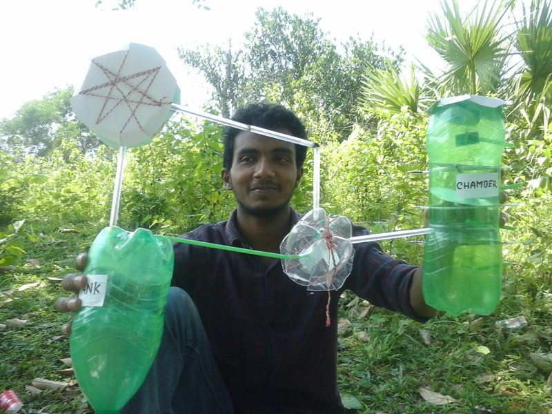

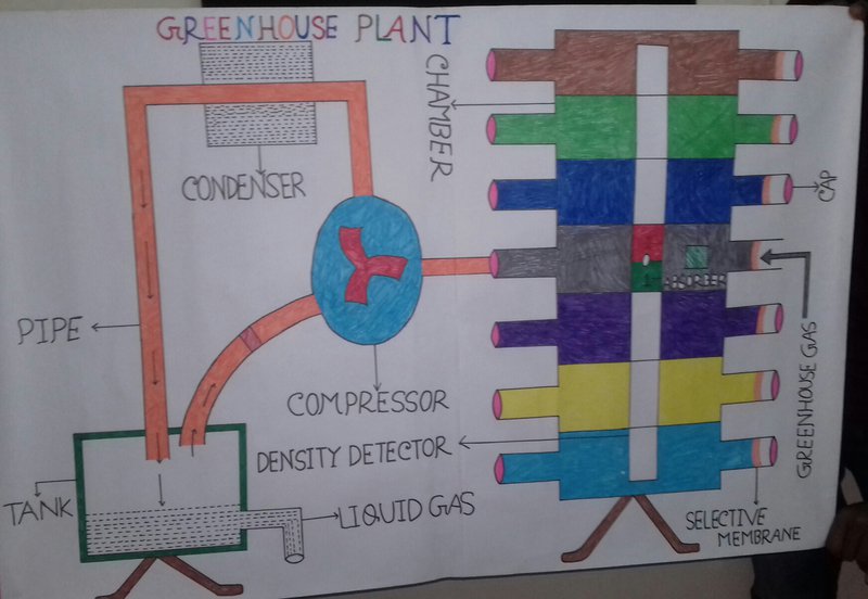
- Our project is the most innovative because we design a GREENHOUSE PLANT which collects green house gases from the environment and convert the gases into liquid form.
- There are separate chambers for collecting individual gases.
- In this plant we use a detector which detects the level of density of gases in the atmosphere.
- We use selective membrane for each type of gases,for example we use synthetic membrane for carbon dioxide.
- Inside the chambers absorber is used to absorb the individual gases.
- The earth will be protected from global warming and the green earth will be established by collecting imbalanced gases from the environment .

SpaceApps is a NASA incubator innovation program.